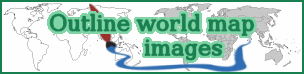
This website provides a set of different outline world map images. These pictures have by default gray scale or transparent continent, ocean and outline (border) areas. You can use also our world map painting tool to create from them colored world map images, choosing such colors, which you like for these map areas.
In other words, this website has two main parts:
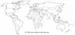
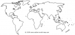
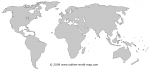
1. outline world map images, which land, water and border areas are white, black, gray or transparent;
and
2. world map painting tool, which can be used for making colored images from the images mentioned in part 1.
The world maps, which are provided on our website, are all royalty free printable world map images and can be used in addition to printing also on websites or for other purposes. These world maps can be used for any legal purposes under few conditions (read more).
Groups of the outline world maps
The map images are divided into separate groups, taking into account the types of them.
The signs for choosing the groups for a set of images can be for example:
* blank world maps
* political world maps
* transparent world maps
* solid color world maps
and so on.
Click here to read more about the groups!
Outline world map painting tool
 As mentioned above, you have on this website the opportunity to paint (replace) the areas on outline world maps with your favourite colors. There have been made a choice of the outline world map images, offered on this site, which can be thought as templates or inputs for this map painting tool. The using of this tool is royalty free, but there are some daily and monthly limits about the number of images, which can be painted in such time periods.
Click here to read more about this painting tool and to start using it!
Terms (definitions) on the website and source image
There are some phrases specified, as follows:
By the phrase outline world map we mean, that the world maps on this website have all following common signs -
the surfaces and borders can have quite approximate shapes instead of very precise shapes; the continents on the maps are surrounded with a (by default) black line.
By using the combination of words blank world map, we are meaning, that there are no country borders on a such map.
The words political world map are indicating on this website to an image, which has country borders (also black by default and with the same thickness as the outlines).
Source: The outline world map images on this website were derived (graphically modified) from a colored map image, which is released to public domain (click here).

